
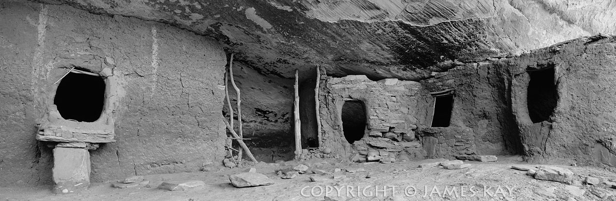
This ancient ruin is one of approximately forty structures scattered along this long ledge beneath the rim of a canyon on the eastern edge of Cedar Mesa in southern Utah. Many were built in defensive positions with loopholes (spy holes) placed strategically in their walls so the occupants could watch intruders entering their canyon without being detected. Tree-ring analysis of the logs used in these structures has revealed that they we built at the very end of the period when people occupied this region around 1300AD. This fact, combined with the loopholes and an adjacent fortress-type structure, gave me the feeling that the ruins along this ledge system were built as a “last stand” fortification against their enemies. The rather remarkable dating technique know as “dendrochronology” analysis relies on the fact that all trees in a climatic region will produce the same patterns of grow rings based on precipitation patterns. Identical patterns can then be overlapped in trees of various ages to travel far back in time to precisely date the exact year that a tree was cut down. This technique was first used in 1917 to date archeological structures in the dry climate of the American Southwest and now provides a continuous unbroken record back to the year 322 BC in this part of the world. For more information visit the University of Arizona’s web page at http://www.ltrr.arizona.edu/archaeology/progandhist.htm This panoramic photograph was captured with a Fuji GX 617 panorama camera.
Print Size | PRINT-ONLY COST | CANVAS-MOUNTED PRINT COST |
|---|---|---|
14″ X 42″ | $475.00 | $750.00 |
17″ X 50″ | $550.00 | $890.00 |
20″ X 60″ | $675.00 | $1110.00 |
23″ x 70″ | $850.00 | $1620.00 |
28″ X 85″ | $1100.00 | $2295.00 |
32″ X 97″ | $1550.00 | Unavailable |
Spaces Available